


Mad Mutt Marine GPS Navigator

Mad Mutt Marine GPS Navigator açıklaması
I started writing this application as something that would be useful to me. Since that it has grown and I am rather pleased with it. It is an aid to marine navigation and must be used in conjunction with charts that are printed on that white stuff that is called (So I’m told) paper.
Features
•Designed by and for a sailor. You may find that some of the layouts look “big and blobby” at first sight, but they work at sea. Fiddly and fussy layouts do not.
•No network required. This app uses your phone’s GPS, it will work where there is no mobile network coverage (though you will need network coverage to share your logs and waypoints by email).
•Store unlimited waypoints (restricted in free version).
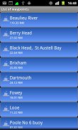
•View waypoints alphabetically of by distance from your current position.
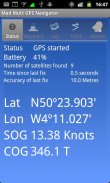
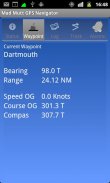
•Display range and bearing to a waypoint.
•Make logs of where you have been, which you can annotate with comments and other relevant data.
•View logs as display on the phone.
•Share logs with Google Earth on your phone or desktop computer, either by email or by copying KML files.
•Share waypoints with Google Earth on your phone or desktop computer, either by email or by copying KML files.
•Share logs with Google Earth on your phone or desktop computer, either by email or by copying KML files. Although I don’t encourage the use of Google Earth for marine navigation, seeing your waypoints on Google Earth is a useful visual check that you have transcribed them correctly.
•Anchor watch alarm service. Alerts you if you have moved more than a pre-defined distance. The anchor watch also alerts you if the battery level is low.
•Near waypoint alarm service
•Once started, the log, anchor and waypoint alarm services will continue to run, even if you quit the main navigator application. They will continue to run while you make phone calls or use your phone for email, Internet browsing or pretty much anything else.
What this application is not
It is not a chart plotter. This application is intended for marine navigation. Although it could be used by ramblers, that isn’t the main intention. It does not display digitised charts, nor does it show you a Google Map view with your position displayed on it. I believe it is highly irresponsible to encourage the use of Google maps to navigate boats. Even in rivers and estuaries, Google maps contain no semantics for the sea whatsoever; no lights and marks, depths, rocks etc. The application does allow you to send logs you have made to Google Maps, though, but only after you have completed the trip.
Free Version
For a limited time, a free version is available. In the Autumn of 2012 a full feature version should be available.
The free version has the following limitations:
•The number of waypoints you can have is restricted to 20.
•Routes are not available
</div> <div jsname="WJz9Hc" style="display:none">Benim için yararlı olacak bir şey gibi bu uygulamayı yazmaya başladı. O bu yana büyüdü ve onunla oldukça memnunum. Bu deniz navigasyon için bir yardım olduğunu ve (Bu yüzden ben söyledim) kağıt denir ki beyaz şeyler üzerinde yazdırılır çizelgeleri ile birlikte kullanılması gerekir.
Özellikler
• tarafından ve bir denizci için tasarlanmıştır. Sen düzenleri bazı ilk bakışta "büyük ve blobby" bakmak, ama onlar denizde çalıştığını görebilirsiniz. Can sıkıcı ve telaşlı düzenleri yok.
• Herhangi bir ağ gereklidir. Hiçbir mobil şebeke kapsama alanı (e-posta yoluyla günlükleri ve yol işaretlerini paylaşmak için ağ kapsama gerekecek olsa) olduğu yerde bu uygulama telefonunuzun GPS kullanır, işe yarayacaktır.
• (ücretsiz sürümü sınırlı) Mağaza sınırsız gezi.
• Bulunduğunuz yere uzaklığına göre alfabetik yol işaretleri.
• Bir yol noktasına Ekran aralığı ve yatak.
• yorumların ve diğer ilgili verileri içeren açıklama, hangi sen nerelerdeydin günlüklerini olun.
• Telefonda ekran olarak kayıtları.
• Telefonunuza veya masaüstü bilgisayarınızda Google Earth ile paylaş günlükleri, e-posta veya KML dosyaları kopyalayarak ya.
• Telefonunuza veya masaüstü bilgisayarınızda Google Earth ile paylaş gezi, e-posta veya KML dosyaları kopyalayarak ya.
• Telefonunuza veya masaüstü bilgisayarınızda Google Earth ile paylaş günlükleri, e-posta veya KML dosyaları kopyalayarak ya. Ben bunları doğru deşifre yararlı bir görsel kontrol Google Earth üzerinde yol işaretleri olduğunu görünce, deniz navigasyon için Google Earth kullanımını teşvik etmese de.
• Çapa izle alarmı hizmeti. Uyarılar Eğer önceden tanımlanmış bir mesafeden daha fazla hareket varsa. Pil seviyesi düşük ise çapa seyretmek de sizi uyarır.
• civarında yol noktası alarm servisi
• Bir kez başladı, günlük, çapa ve geçiş noktası alarm hizmetleri ana navigasyon uygulamasını çıkmak bile çalışmaya devam edecektir. Telefon görüşmeleri yapmak veya e-posta, Internet tarama veya başka hemen hemen her şey için telefonunuzu kullanmak Onlar çalışmaya devam edecektir.
Bu uygulama ne değildir
Bu bir grafik çizici değildir. Bu uygulama deniz navigasyonu içindir. O ramblers tarafından kullanılabilir, ancak bu ana niyeti yoktur. Bu dijital grafikleri görüntülemek değil, ne de size bu görüntülenen pozisyonu ile bir Google Map görünüm göstermektedir. Ben tekne gezinmek için Google haritaları kullanımını teşvik etmek son derece sorumsuz olduğuna inanıyorum. Hatta nehirler ve nehir ağızlarında, Google haritalar olursa olsun denizde hiçbir semantik içermez; hiçbir ışık ve işaretleri, derinlikleri, uygulaması Google Maps rağmen, ancak yolculuk tamamladıktan sonra yaptık günlükleri göndermenize izin vermez vb kayalar.
Serbest Sürüm
Sınırlı bir süre için, ücretsiz bir sürümü mevcut. 2012 Sonbahar tam bir özellik sürümü mevcut olmalıdır.
Ücretsiz sürümü şu sınırlamaları vardır:
• Eğer olabilir yolnoktalarının sayısı 20 ile sınırlıdır.
• Rotalar mevcut değildir</div> <div class="show-more-end">
Mad Mutt Marine GPS Navigator - Sürüm 1.07
(04-08-2014)
Mad Mutt Marine GPS Navigator - APK Bilgisi
APK sürümü: 1.07Paket: uk.ac.plymouth.madmutt.gpsnavigatorMad Mutt Marine GPS Navigator uygulamasının en son sürümü
Diğer sürümler


Aynı kategorideki uygulamalar

Hoşuna gidebilecekler...


